It has been a breath taking journey North on the Alaskan Highway as I enter the Canadian Rockies. I have quiet a few shots as you can imagine, but in treating myself to the 'most expensive' RV camp on the Highway (rationalized as they offer internet service) I discovered that the WiFi - such that it is - only delivers 50kb down and 20Kb upload. I could be here for the next month in a attempt to show you one shot, so I'll have to wait until I reach Watson Lake, YT later this week. I am using the time here to clean and work on photos.
I finally saw some wildlife on the road - a young moose drinking in a puddle (it rained here) at a turn off and two separate sightings of black bear cubs - no mommas. Got photos of the first but not the bears.
Muncho Lake is a beautiful long lake nestled against the Rockies. I wanted to see the sunset last night, but by now being north of the 58th parallel it doesn't really set. Midnight it is bright enough to read and you sure don't see stars. Hard to get sleep at night!!
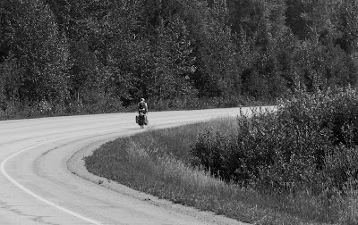
The roads are good with normal summer construction in places, but over all not bad. I have found the sweet spot for the MoHo at 2200RPM or about 55MPH. Speed limits are posted at 100KPH (about 60MPH) but I have yet to see anyone but me drive at the post limit. I have reached that place where I'm not in a hurry and want to see the scenery so go ahead and pass me. I also care about my rig and won't go very fast on some of these 'washboard' surfaces. It just seems that when I spot a great view, there is no pull over spot and the 'shoulder' doesn't exist. But I have found plenty, I my 'mind's camera' has seen them.
I will leave in the am, headed to Liard Hot Springs, at least for some shots, and then either stay the night or push on to Watson Lake.
Monday, July 13, 2015
Friday, July 10, 2015
Alaska Highway Mile "0" - Dawson Creek

Dawson Creek is a small town that became famous in 1942 as the starting point for the Alaska Canada Military Highway that was built to supply Alaska with material for the fight against Japan, who were at the time in the Aleutian Islands. They got this honor by being the 'end of rail' in this part BC, and that was because when the railroad was being built at the turn of the century, the railroad didn't want to pay the extra money a farmer wanted for his land in nearby Pouce Coupe. Even little things can have huge consequences later. Personally, I'm glad the farmer didn't make the deal as the Alaska Highway would start in Pouce Coupe and not Dawson Creek. Better name for a starting point, don't you think??
I'll start the journey on the Highway tomorrow. The fires that closed the road a couple of days ago are better or just moved on, and rain has been expected. Remember - once you start the route North there are no off ramps until you hit the Yukon Territory and that is to go back on the Cassir Highway.
This morning was unique in that I needed to wear a jacket this morning - 57 degrees.
It doesn't take long to see the sights here and much is built around the tourists who travel the Highway and like most such places the locals try to stay out of the way of us.
Here's a shot of the Bijoux Falls I shot a few days ago - Days blend together (if it wasn't for the pill case I use I'd forget what day of the week it was).

Onward and Northward. Leave a comment if you have gone this far and I'll know 'I'm not alone'.
Wednesday, July 8, 2015
A little catch up
Today is my 4th day in Canada and aside from discovering that the Canadians do not drive anywhere close the the speed limit and their deodorant of choice is Off bug repellant ('cause the mosquitoes and flies will carry you away), I have had a great time exploring the southern parts of BC (British Columbia for most of you).
I'll not rant about the cell phone companies and their obvious collusion with American providers that force you to use your service with all the roaming charges and data fees (Verizon wants $.99/min for calls to/from and $2.05/mg data. Who can use data in MG anymore??) Nor will I rag about my bank - whom I called to tell them I was going to Canada and still froze my account - that took a $25 phone call to get a "we sorry this happened", but all's well now.
Passing thru Canadian Customs was not difficult - I was the only one for about twenty minutes.

Leaving USA in entering Canada
Headed West on highway 3 to Osoyoos to pick up highway 97 that I will follow most of the way to Alaska. This was the Okanagan Valley that is very much like Lake Region of Italy with lots of Fruit farms and wine producers. Since July 1st was Canada Day, everyone is beginning their summer holidays and there was 'no place at the inn..', so I resorted to camping in the Walmart parking lot with a couple of other seasoned travelers. No Worries, eh! I did treat myself to a very good Canadian steak and good dinner. I did miss the Women's World Cup - but yeah USA!!!
The litany w/o wifi is to stop at Starbucks and use their wifi and go to Tourist info (I am a tourist after all) to check on wildfires to help shape my trip. Conclusion: the Northern Hemisphere is aflame!!!
My second night was in Wells Gray Provincial Park just north of Kamloops. Beautiful place, if it weren't for the bugs (Off!!)

Helmcken Falls

Dawson Falls

Pier at Clearwater Lake - Short walk anyone?
From here I drove ever Northward to the East of Wells Gray Park - it is huge - I came to rest last night in Prince George.

All methods of travel here in Canada.
I declared a 'make and mend' day (reading too many old sailing novels set in the 1700's). Cleaned the coach, did the laundry, and then worked on photos and now the blog. There is so much to see and fortunately the natives are great - except behind the wheel of a vehicle.
Tonight I study the old 'Milepost' for the road from here to Dawson Creek and the beginning of the Alaska Highway. I think I will also stop here for two days and stay up on the blog and see the 'sites'.
Talk later
Please leave a comment - it's nice to know someone is looking at these ramblings of mind beside my good friend David.
Sunday, July 5, 2015
Crossing over today
Got up early to download my fireworks shots from last night, some good, and then write this and go through email land. Packing up and leaving for the North as soon as I can tidy up.
Spokane has been a good layover - temperatures aside - so here is a last look and the beautiful riverfront last night.


Spokane has been a good layover - temperatures aside - so here is a last look and the beautiful riverfront last night.

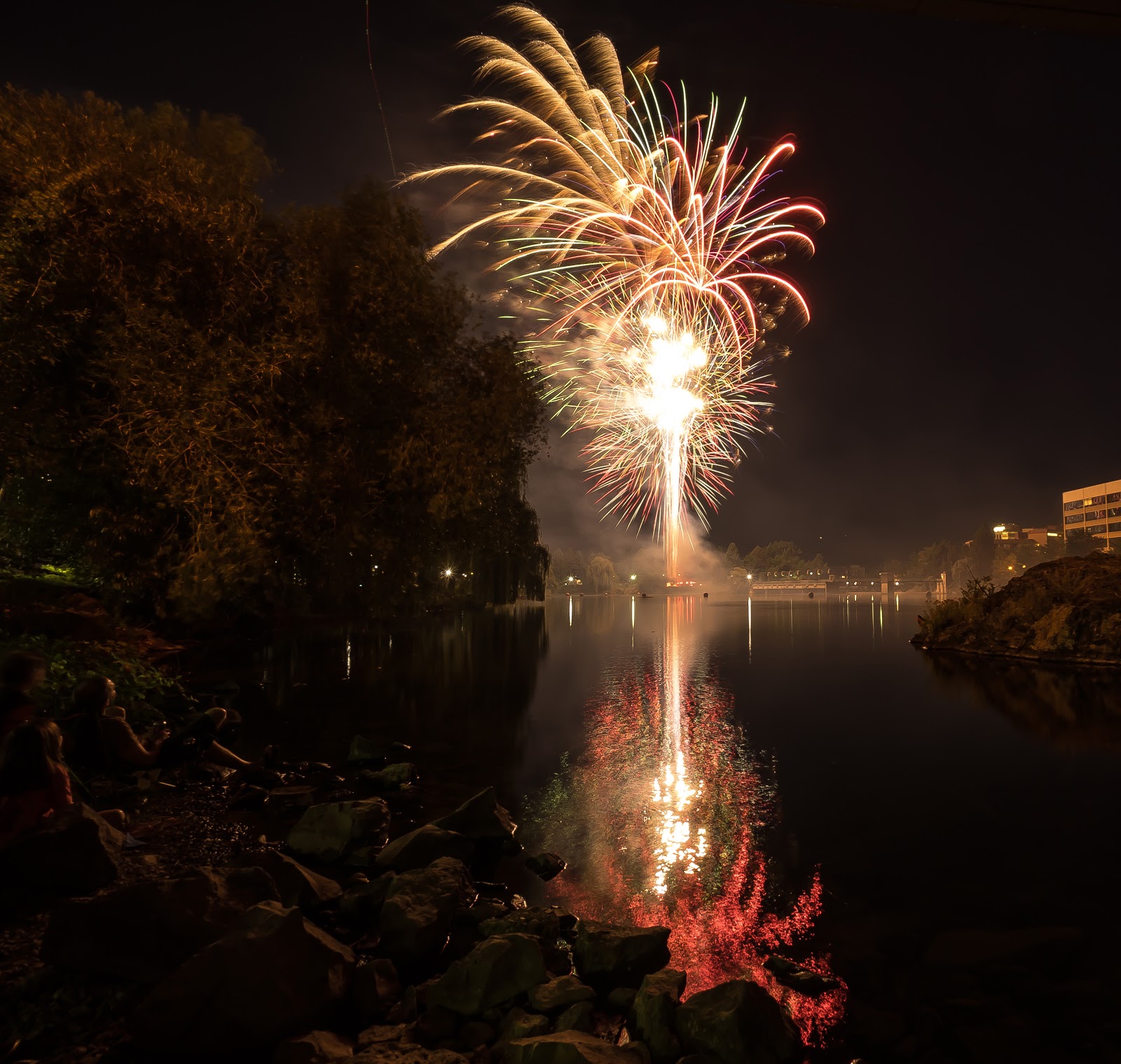

All shot from under the Division Street Bridge. Great show. (I think I did pretty well for the first time shooting fireworks. INFO: ISO 80; f11 at 10sec with Sony a7 and SEL1018 at 12mm)
More later
Saturday, July 4, 2015
Twice in One Day
Don't get use to it. I'll be turning off my cell phone while in Canada and buying a chip from a local telecom to put into my iPad to be used for email, apps, and Face Time as well as a hotspot for the computer here - and at a much better rate of $10/100MB.
Since I had time - waiting for cooler (It is all relative) temps and the fireworks tonight - I thought it would be nice to show you a map of the journey so far.
Leg One was from home in Oxnard California to Truckee, CA to drop my great nephew Ethan off at his parents.


Since I had time - waiting for cooler (It is all relative) temps and the fireworks tonight - I thought it would be nice to show you a map of the journey so far.
Leg One was from home in Oxnard California to Truckee, CA to drop my great nephew Ethan off at his parents.

The times are if you were to drive it straight through, eh!
I stayed with family for over a week, and that was fun being around the folks I so seldom get a chance to see, but I felt it time to move on, before I was asked to.
The second part is from the Truckee area, joining back to US395 and going all the way to the Canadian border. That last bit I will do tomorrow when I leave here in Spokane.

It has been a hot trip through the high deserts of Northern California, Oregon and past the Columbia River Basin in Washington. I know I would have stopped a few more times, but I was melting.
More of the trip to come and I'll do another map when I cross into the States again, I mean Alaska.
Happy Fourth of July
I have stayed in the MoHo this morning - going thru the last weeks pix - and staying in the cool. I will venture forth this evening to go back to the riverfront for the fireworks. Yesterday was brutal - 105F - but I made the Riverfront Park my main destination. The Spokane River Falls are quite long and comprise at least four levels. Seems to be plenty of water, but it may be lower than normal, but to a water starved SoCal resident - it was a lot.


There is another series of falls to the left and also lower down to the right. This looks to the Pavillon and the Water Plant on the right.
Spokane is a fun place, people are friendly and were it not for the heat I may have gotten some Kettle Korn myself.

Yes they are on a bit of a slope to the left. Guess the bib overalls are a 'uniform'??

There are a few 'ghost paintings' still on the side of many downtown building, though this one also has a canvas stretched on the side.
Here is a view from a rest stop southwest of Spokane over looking Lake Sprague.

A little further south in Oregon (I said I had time to work on photos) this was a common site as the farmer watered their fields to grow mostly hay.


And of course the odd old farm house or watermill. Don't know if this one is still working!!?
Hope you all have a save and enjoyable 4th and may no fires disrupt your evening.
Thursday, July 2, 2015
Pendleton - 105
Last night was spent in an oasis of a campground on the John Day River - quiet, green and cool. After traveling in upper 90's the cool watered - no drought here! - site was ideal. I have decided to shower after a long hot day, instead of a hot shower in the am. Cools me off and saves gas by not heating the water - it is warm enough riding in the heat.
Today started in the John Day Fossil National Park - John Day was a trapper in the oldest days and became famous by getting robbed of all his possessions, including his clothes (some say Indians took them - others bad guys). In eastern Oregon, John Day is famous and because this is where he lost his clothes. Beautiful volcanic hills, great streams (all John Day Rivers - Upper, lower, middle), and now hot.

 Cathedral Rock
Got to Pendleton about 1PM and it was 102F. There was a funky old downtown, but I couldn't find a place to park the MoHo - they put signs up against them parking. Went to Walmart - I know, but they have BEF for the diesel. When all was done - 105F and only 3pm. I was thinking about staying for the 4th here but several people I asked just shrugged their shoulders and didn't know of any town plans. Out of here!
I'm now into Washington, the radio - NPR - says that heat wave is through the weekend, but Spokane has a celebration along the waterfront. It won't be cooler, but there will be fireworks.
Later
Today started in the John Day Fossil National Park - John Day was a trapper in the oldest days and became famous by getting robbed of all his possessions, including his clothes (some say Indians took them - others bad guys). In eastern Oregon, John Day is famous and because this is where he lost his clothes. Beautiful volcanic hills, great streams (all John Day Rivers - Upper, lower, middle), and now hot.


Got to Pendleton about 1PM and it was 102F. There was a funky old downtown, but I couldn't find a place to park the MoHo - they put signs up against them parking. Went to Walmart - I know, but they have BEF for the diesel. When all was done - 105F and only 3pm. I was thinking about staying for the 4th here but several people I asked just shrugged their shoulders and didn't know of any town plans. Out of here!
I'm now into Washington, the radio - NPR - says that heat wave is through the weekend, but Spokane has a celebration along the waterfront. It won't be cooler, but there will be fireworks.
Later
Subscribe to:
Comments (Atom)